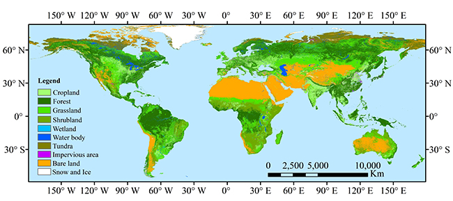
The first 10-m resolution global land cover map
The first 10-m resolution global land cover product (FROM-GLC10) was successfully realized by the research team led by Prof. Gong Peng from the Department of Earth System Science, Tsinghua University, cooperating with domestic and international institutions. This work titled “Stable classification with limited sample: transferring a 30-m resolution sample set collected in 2015 to mapping 10-m resolution global land cover in 2017” has been published in Science Bulletin that presents the methodologies and results of the first 10-m resolution global land cover map.

FROM-GLC10 2017 based on 10 m resolution Sentinel-2 images
The development of world often faces many challenges, such as population growth, urbanization, agricultural development and impact of climate change on food security, energy and water shortages, overexploitation of resources, biodiversity loss and environmental pollution. In order to ensure the peoples’ well-being and achieve the United Nations’ sustainable development goals, the timely and high-resolution land cover information is needed that permit to provide a better environmental monitoring. However, the first 30-m resolution global land cover map (FROM-GLC30) did not come out until 2012 that was realized by Tsinghua University.
In recent years, more and more demands of the global land cover maps with higher spatial resolution are emerging. Based on the research work in producing 30-m resolution global land cover map and accumulation of sample library construction, complete storage and free access of 10-m resolution Sentinel-2 global image, as well as powerful cloud computing capabilities of Google Earth Engine, Gong et al. developed the first 10-m resolution global land cover map.
This work proposed the theory “Stable land cover classification with limited global sample”, pointing out the requirements for minimum sample size and error limits for remote sensing data obtained by global training samples moving to other years or different sensors. The accuracy of the 2017 FROM-GLC10 map was compared with the 2017 FROM-GLC30 map. The results show that the overall accuracy of FROM-GLC10 product is 72.76%, which is comparable to the one of FROM-GLC30 product.
The FROM-GLC10 product is now officially available worldwide and can be downloaded free of charge at http://data.ess.tsinghua.edu.cn.
Original link: https://www.sciencedirect.com/science/article/pii/S2095927319301380

